In so many parts of the world, increasingly frequent extreme weather is becoming a bigger and bigger problem. But even knowing that, it can often be difficult to envision exactly how these types of events will affect us — often until they've already happened.
That's where FloodVision, an ambitious new project from the Sea Level Rise program at the nonprofit Climate Central, comes in.
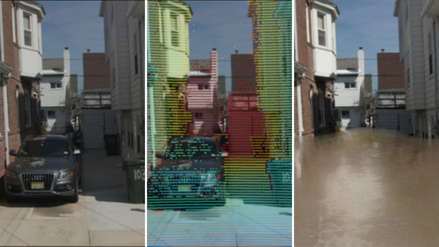
FloodVision uses advanced data collection techniques, AI-based algorithms, and intuitive software to produce augmented-reality photos of specific locations. In short, it can show you exactly how extreme storms and rising sea levels could tangibly alter where you live.
"Photorealistic images of familiar places have always been our most powerful tools to illustrate scientific projections, but they're time-consuming to create," Dan Rizza, manager of the Sea Level Rise program, told The Cool Down. "With FloodVision, we finally have a way to scale the creation of images with scientific precision to show people what storm — and sea-level rise-related risks mean to them at the local level."
The idea of FloodVision is not just to show people what their homes will look like when flood waters hit them. The project's creators hope that it will inspire people to take action to prevent worsening events in the future.
Still in an early stage of development, FloodVision recently faced its first big test when Climate Central presented at The Aspen Ideas: Climate festival in Miami.
TCD Picks » EDF Spotlight
💡EDF's Vital Signs newsletter delivers stories about game-changing solutions close to home and around the world


"Bringing the equipment to a new environment, gathering the data, and processing it remotely to produce images more or less on demand was something new for us," Rizza said. "We barely had time to review the results before we showed them onstage, to local officials, to media outlets — and the response we got was very positive."
That last-minute hustle makes sense, considering FloodVision required an enormous amount of technology and scientific expertise to create.
"Our big challenge was adapting and integrating technology that was never intended to create work like this," Rizza said. "The mechanics, the engineering, the computational science to manage these data streams, were all breaking new ground."
And although the technology behind FloodVision is complex, the goal of its creators is to make it as easy to grasp as possible. After all, warming temperatures, extreme weather, and flooding affect all of us.
"The risks that so often seem abstract became real and local for the people who saw the work. It's our hope that FloodVision can be used to show flood risk but also show the advantages of investing in resilience and flood protection measures — to see what flooding could look like if action isn't taken," Rizza said. "FloodVision is an example of turning potentially overwhelming information into clear ideas that make it easy to understand and communicate the risks posed by climate change."
And you don't need to be some sort of programming genius to help act on the message behind the project.
"I've never seen so many people and organizations paying so much attention to climate change," Rizza said. "So much of that surge of interest is a result of individuals who see the upcoming risk and want to do what they can to reduce it."
Rizza added that those looking to make a difference in their own communities should focus on what they can do, not what they can't.
"You don't need to work for an entity focused on climate change to make a difference," he said. "So many of the solutions that will reduce flood risk and carbon pollution will come from various sectors of society made of individuals with various skill sets."
Join our free newsletter for weekly updates on the coolest innovations improving our lives and saving our planet.