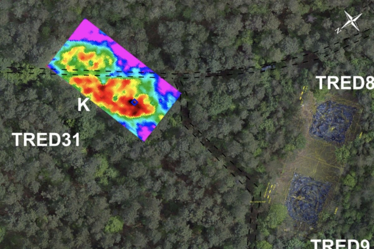
Archaeologists in western France have uncovered new clues hidden inside 6,000-year-old Neolithic burial mounds, though the findings are not quite as dramatic as some descriptions suggest. Rather than hidden human remains, the scans appear to show buried stone features set within the huge earthen barrows.
What's happening?
In a 2026 study, archaeologists Philippe Gouézin and Vivien Mathé investigated two long barrows at the Coëby Neolithic cemetery in Trédion, Brittany, using electrical resistivity surveying, a noninvasive technique that highlights contrasts between buried stone and surrounding soil.
As Arkeonews reported, the readings showed strong high-resistance bands along the middle of both mounds, pointing to stone-built features below the surface.
The site has attracted researchers' interest since 1986. Excavations in the 1990s at one mound, known as TRED36, revealed a pair of human-shaped standing stones buried inside the mound rather than set on top of it.
That earlier discovery raised a broader question: Were those anthropomorphic stones unusual, or were they part of a larger pattern across the cemetery?
The newly scanned barrows, TRED30 and TRED31, are large. These earth-and-silt mounds typically measure around 50 to 80 meters (164 to 262 feet) long, 25 to 40 meters (82 to 131 feet) wide, and up to 1.8 meters (5.9 feet) high.
TCD Picks » Quince Spotlight
💡These best-sellers from Quince deliver affordable, sustainable luxury for all




At TRED31, researchers detected two especially intense anomalies near the mound's central axis, and the larger signal probably reflects multiple stone features clustered together.
Why does it matter?
The results support the idea that these barrows were designed as monuments with hidden stone elements inside, not merely as simple accumulations of earth.
That, in turn, gives archaeologists a better sense of how Neolithic communities may have structured ritual spaces and commemorated their dead.
The discovery also helps place Brittany within a wider prehistoric tradition. The researchers said the Coëby barrows resemble Passy-type barrows, a category of monumental earthen tombs found in other parts of France and belonging to the Middle Neolithic around the 5th millennium BCE, according to Arkeonews.
If that comparison is accurate, it could suggest that people across distant regions shared architectural ideas and funerary practices.
There is also a preservation concern. The survey showed that a forest access road has cut one mound and that about 20% of TRED30's footprint may already have been lost to leveling and erosion.
What's being done?
Because it can be used before excavation, electrical resistivity mapping gives researchers a way to examine fragile sites while leaving their archaeological context largely intact.
In this case, the team surveyed roughly 3,000 square meters (32,300 square feet) at different depths to build a clearer picture of what lies below the surface, Arkeonews reported.
The scans still cannot tell archaeologists exactly what each buried stone feature is. Some anomalies may be standing stones, while others could be stone-lined structures or grouped blocks.
The team suggested that future work could use electrical resistivity tomography, a more advanced 3D imaging method, to refine the findings before any excavation is considered.
Methods like this can increase what experts know about cultural heritage while also limiting harm to the sites themselves.
For now, much of Coëby's story remains underground. Still, the survey suggests the cemetery may hold additional concealed stone monuments — not literal bodies, but intentionally placed stone forms that may yet reveal more.

Get TCD's free newsletters for easy tips, smart advice, and a chance to earn $5,000 toward home upgrades. To see more stories like this one, change your Google preferences here.